Showing posts with label Volunteers. Show all posts

Thursday, 25 July 2013

What's next for #DigBromsgrove?

Our volunteers finished work on the site last Friday. One of the really important aspects of this excavation has been the way that everything -  from doing the initial clean to setting out the grid, drawing the plans, taking levels, digging the features, taking site photographs and filling out the record sheets - has been done by the volunteers. The professionals have been on hand to guide them every step of the way, but our volunteers have gained valuable experience of every aspect of an archaeological dig - hopefully, they've all learnt that there's a lot more to archaeology than digging holes!

Hazel and Dave filling out Context Sheets for the cellar
 All of this hard work meant that Richard and Rob had a stress-free day on Saturday, finishing off the recording, doing some final drawings and checking that all the paperwork was in order. Each different deposit, structure and feature is assigned a unique 'Context Number', which is used as the reference for finds, drawings and photographs relating to it. All of this information is collated on a 'Context Sheet', in addition to information about the relationship of the context to others around it, i.e. whether Context X (e.g. a yard surface) is earlier or later than Context Y (e.g. a wall). Also included on the Context sheet are dimensions, location information and the archaeologist's interpretation of what the context is is and how it relates to the rest of the site.

Context sheets can be tricky, especially on an urban site like DigBromsgrove, as it's not always easy to tell how a context fits in to the sequence of a site. People often assume that the deeper down in the ground something is, the older it is, but this isn't necessarily the case! For example, on this site we have a cellar, filled with 1940s and early 1950s household debris, which was the star of one of our previous blog posts. In this case, the deeper deposits are later than some of the surrounding features at a higher level, because they were filling a cellar that had, centuries before, been dug down through earlier levels.

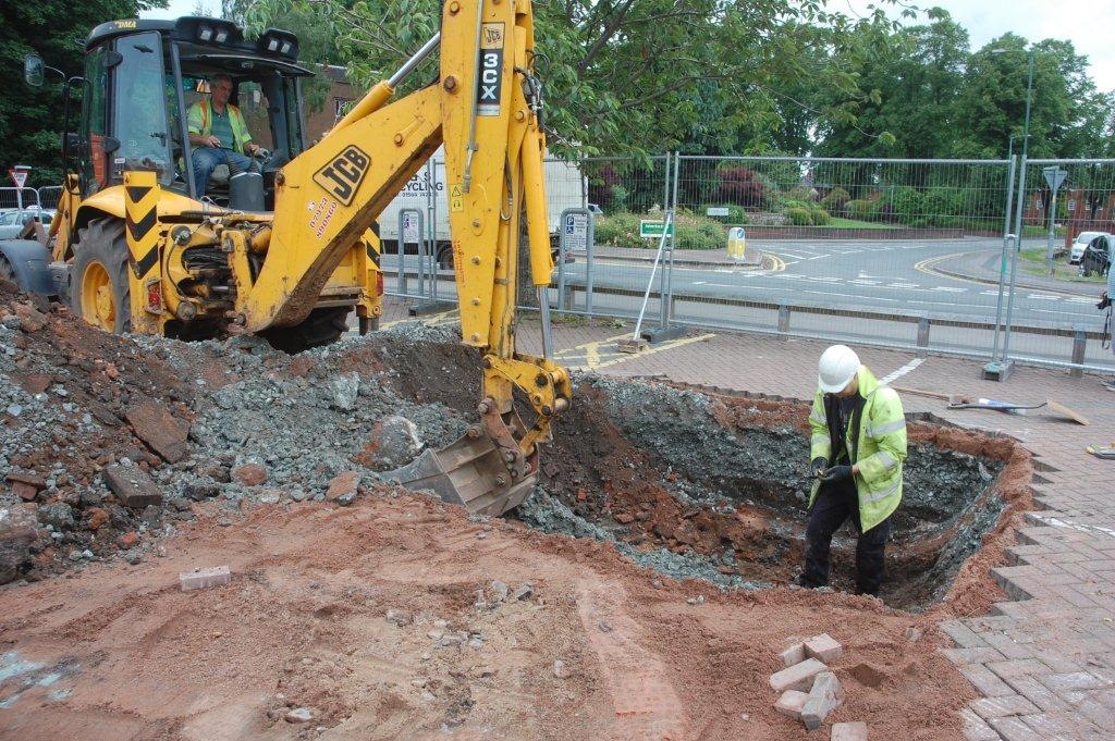
Richard puts the final touches to the paperwork. In the foreground, Rob has set out a horizontal string line to draw the profile of the cellar wall...


...and here's the finished drawing.
 Thankfully, our volunteers did a really good job, which makes our lives a great deal easier! One final task we had to complete was to finish off the 'sondage' (a small trial hole) excavated in the northeast corner of the site, against the exterior edge of the rear wall of No. 4, in order to try to discover whether any traces of pre-17th century occupation exist on the site. One tiny piece of pottery that we discovered may hold the key: watch this space!

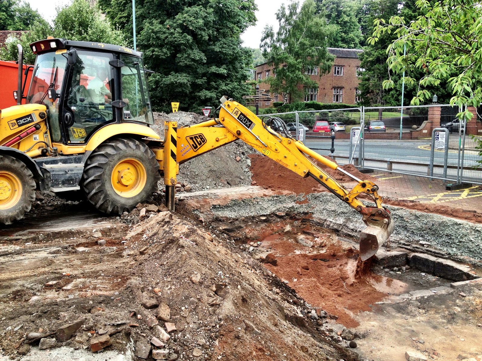
On Monday, the exhibition was packed up and moved to Bromsgrove Library, where it will remain over the summer. Pop along and take a look - some of our finds are on display along with maps, photographs and some background information. The site was filled in using a JCB, with sand being laid down first to protect the archaeological features. Many people have asked us why we can't keep it open. The answer is that, besides the obvious problems of having a large hole open in the town centre, covering the site over is the best way to protect the archaeological remains. Left exposed to the elements, sites can quickly deteriorate.


The site is backfilled by the 'Big Yellow Trowel'! Sand is laid over the top of the archaeology to protect the features.
 So what's next? Well, all the records and finds are now back at our offices in The Hive, Worcester. This week our finds volunteers have been continuing the process of cleaning, cataloguing and labelling the artefacts unearthed by the dig. They'll be analysed by our specialists, and once Site Director Richard Bradley has returned from a very well-deserved holiday, we'll begin the process of post-excavation analysis!


The finds, awaiting processing by our finds volunteers at The Hive, Worcester. The labels on each bag tell us which context the finds have come from.
 We'll continue to keep you all updated on the progress of the work, so keep checking in here to follow what we're up to. Hopefully, we'll soon have news on that tantalising piece of pottery! In the meantime, don't forget to take a look at our photographs on Flickr - more coming soon!

Rob Hedge

Friday, 19 July 2013

Cobbles, Walls and Tiles galore!

This week, besides uncovering the lovely finds from the infilled cellar, our volunteers have been patiently and steadily working away elsewhere on the site to expose more of the structural features of the buildings that once lined St John Street. As we move into the last day of excavation with our lovely team, we'll be photographing, drawing and filling out the paperwork that will become the lasting record of these features.

The inner face of the cellar wall, No. 6

The picture above shows the very nicely built sandstone block wall that formed the west facing wall of the cellar of No. 6. In the centre of the photograph you can see a patch of red sand covered by concrete, encasing an electricity cable that cuts through the wall. It was laid during the building of the Market Hall in the 1990s.
Modern service cables are a common feature on archaeological sites in urban areas! In this case, we've been lucky, as apart from that cable and a drainage pipe in the southwest corner of the site, there has been very little modern disturbance.

Volunteer Joyce exposing the cobbled yard surface at the rear of No 5

The cobbled surface shown in the photograph above would once have been the back yard surface of No 5. Cobblestones were a cheap and very hard-wearing surface before the advent of Tarmac and concrete, and were a common feature of pre-20th century yards.

The tiles that once formed the floor of a passageway between Nos 4 & 5

In the northeast corner of the site, we've removed layers of demolition rubble and mortar to expose a very nice tiled surface, which we believe was the floor of the passageway that divided Nos 4 and 5. In and around this area we're finding fragments of 17th and 18th century pottery: tantalising glimpses into the lives of the early occupants of these buildings.

Come along this afternoon, Friday 19th July, for our final organised site tour - no need to book, just turn up at the gate for 14:00. See you there!

Rob Hedge

Wednesday, 17 July 2013

We love it when a 'plan' comes together...

Our volunteers putting the finishing touches to a scale plan

Over the past few days, if you've taken a look in our trench you'll have seen groups of volunteers drawing scale plans of the site, using the grid that we talked about in the last blog post. We've had a few interesting questions about the role of technical drawing in archaeology, so we'll try to answer them here!

Why don't you just take a photograph?

We do take photographs! Lots of them, in fact. The photographs form an essential part of the site archive. Every part of the site is photographed with a scale and a north arrow, and the details of the photograph (number of the feature, size of scale bar, related drawings) is noted in a register.
However, photographs can't tell the whole story. Perspective makes objects further away from the lens appear closer together, and whilst this can be corrected by digital rectification, this tends to result in a loss of quality. These problems can be overcome by using complex pieces of kit like the pole-mounted cameras used by Adam Stanford at Aerial-Cam, but....
...Another problem with photography is that it tends to 'flatten' features: it can be difficult to get a sense of depth and angle of slope through a photograph, and that information is crucial to interpreting archaeological sites.

So, why don't you just survey the site electronically?

Again, we do! It is standard practice on many archaeological excavations to survey the site using a 'Total Station' or GPS/GNSS staff-mounted survey units. This overcomes the distortion and 'flattening' effects of photography, and can produce an extremely accurate digital plan quickly and easily. However, there are details that we need to record that don't show up on an electronic plan. For example, one of the important functions of a plan is to record differences in the composition of different deposits. Is there variation in building materials? Flecks of charcoal in one area? A high proportion of stone in a layer? All of these details can be easily and quickly recorded in hand-drawn plans and sections (drawings of vertical faces).

Another reason for planning by hand (and I have to admit to being biased here, as planning is probably my favourite part of site work!), is that it really helps you to interpret the site, and forces you to take a really close look at what you're dealing with. Besides, many of the volunteers we're working with won't have access to expensive electronic survey equipment for their own archaeological projects, so it's important for them to learn the skills needed to do the whole process the old-fashioned way!

All our plans are drawn on 'drafting film', a translucent sheet printed with grid squares. Drawing is done with a hard pencil (usually 6H) at an agreed and consistent scale - in this case, 1:20 for plans and 1:10 for sections. One of the advantages of a translucent sheet is that drawings of different phases of the site as the layers are peeled away can be 'overlaid' to compare them.

So, next time you see us with drawing board and pencil in hand, you'll know what we're doing and why! Here's a photograph of one of the finished articles, all surveyed, drawn and levelled by our volunteers - Not bad for a first attempt!

Rob Hedge


Saturday, 13 July 2013

Finds ID day today, and site progress report

To kick of the Festival of Archaeology, which starts today, we're holding a finds ID day:

Found pottery in your garden? Picked up something unusual whilst walking the dog? Bring along your own archaeological finds to our exhibition between 10:00 and 16:00 today, where Worcestershire Archaeology finds specialist Laura Griffin will be on hand to identify them.

On site, we've finished the trowel clean of the site, and photographed the results. We're pleased with the progress - taking the time to do a really thorough initial clean has paid off, as the structures and features are now showing up really clearly.

The next stage is to draw up a scaled 'pre-excavation' plan of the site, before we start to dig into the archaeology. To do this, we need to set up a grid, from which we can then lay out tape measures to accurately plan the features. Each grid peg is labelled with an 'easting' and a 'northing', from which we can plot the location of any of the features and structures on the site.

Setting out the grid

Grids on most archaeological sites are set out electronically and located by GPS, but the ability to set one out the old fashioned way using tape measures, grid pegs and trigonometry is still an invaluable skill for an archaeologist for those occasions when technology lets you down!

Admiring the results!
Drawing the scale plan, with guidance from Worcestershire Archaeology's Tim Cornah
This weekend, we'll be starting to excavate into the deposits that we've exposed and planned. We'll also be cleaning and cataloguing the finds we've recovered so far, which will go on display in our exhibition on the High Street.

Rob Hedge

Wednesday, 10 July 2013

Digging has begun!

Yesterday, the first of our volunteers arrived on site for the first day of the #DigBromsgrove excavation. One of the questions we were asked by a visitor is how the process of setting up an archaeological excavation takes place. So, here's a quick introduction to how we got from car park to archaeological site.


Site chief Richard Bradley directs the machining


Last week, we marked out the area to be excavated, then removed the modern deposits associated with the Market Hall and car park with a JCB. The machining was directed by Richard Bradley, the archaeologist in charge of the excavation.

It may sound strange to start a delicate and painstaking archaeological dig with a big mechanical excavator, but with a skilled driver and careful supervision, it is possible to remove very precise layers of material by machine. This Youtube video is a great demonstration, as Time Team's star digger driver Ian Barclay peels a banana using an excavator! As soon as we reached the archaeological deposits underneath the modern levels, the machine stopped and we awaited the arrival of our volunteers.

The site, machined and ready to be cleaned
The first crucial task on any archaeological excavation is to give the site a good 'clean', which in archaeology-speak generally means removing any loose material left by the machine, and then scraping back the top surface of the archaeology with a trowel. The aim is not to 'dig', but rather to reveal the archaeology more clearly. A good analogy is to think of sanding a tarnished piece of wood -  removing a very thin, even slice helps to bring out the grain in the wood, as a good trowel clean helps the archaeology to show up clearly.

The 'clean' is essential because before we start 'digging' down through the deposits, we need to have a clear idea of what we're looking at across the site. It will help us to start to think about the relationships between the different phases of archaeology and features across the site, and to plan which layers we'll excavate first.

After the first day, the site is already looking a lot cleaner, and the features and deposits are starting to appear as our hard-working volunteers toil away in the sweltering heat.


Our Volunteers giving a lovely demonstration of good trowel-cleaning
 Today, we'll continue the cleaning, and hopefully we'll be able to start seeing how the archaeology in our trench matches up (or not!) to the historic maps we've been studying. Fingers crossed!

Rob Hedge